Crustal Velocity Structure of the Middle-Southern Segment of the Tanlu Fault Zone (China) and its Correlation with the Seismic Activity in the Region
-
摘要:
郯庐断裂带中南段为中国东部规模最大且第四纪活动性最为显著的活动断裂,该断裂带不仅存在地震频发区,还存在地震空区,在南段的郯城1668年曾发生过8.5级大地震。为揭示该断裂带地壳速度结构,探讨速度结构与地震活动性之间的关系,本研究利用郯庐断裂中南段附近的121个固定地震台的P波和S波震相数据,采用天然地震层析成像方法(TOMOG3D),对研究区内
8886 个地震事件进行重定位,获得研究区下方地壳内三维P波速度(VP)、S波速度(VS)及纵横波速比(VP / VS)结构。层析成像结果表明,①郯庐断裂带中南段表现出显著的速度分段特征,可分为郯城以北段、郯城−明光段、明光−武穴段;②大地震主要分布在高、低速交界处;③速度结构与地震活动分布具有较好的空间对应关系,宿迁地震空区下方存在明显的低速异常。本研究结果为深入理解郯庐断裂中南段的地质构造动力学过程以及地震活动分布的关联性提供地震学证据。Abstract:The Tanlu fault zone is the largest and most active Quaternary fault in eastern China. An M8.5 earthquake occurred in
1668 in Tancheng City located on the southern segment of the Tanlu fault. In this study, we analyzed the crustal velocity structure of the Tanlu fault zone and assessed its relationship with the regional seismic activity, using a large dataset of the arrival times of the primary (P) and secondary (S) waves recorded at 121 permanent seismic stations in and around the middle-southern segments of the Tanlu fault; in total, we used the data of8528 local earthquakes. We developed three-dimensional (3D) images of the P-wave (VP) and S-wave (VS) velocities and the VP / VS ratio, using the TOMOG3D (a seismic tomography method). The tomography results revealed the following features: (1) a significant velocity segmentation feature exists in the middle-southern segments of the Tanlu fault zone; this feature can be divided into Section A (located in the north of Tancheng), Section B (extending from Tancheng to Mingguang), and Section C (extending from Mingguang to Wuxue). (2) Large earthquakes are mainly distributed at the junction of the high- and low-velocity anomalies. (3) A strong correlation was noted between the velocity structure and seismic activity, especially in Suqian (where a clear low-velocity anomaly that corresponded to a seismic gap was observed). Our study provides new insights into the crustal heterogeneity and seismic activity in the middle-southern segments of the Tanlu fault zone. -
郯庐断裂带是一条典型的纵贯中国东部的深大断裂带,呈南南西−北北东走向,自南向北穿过多个构造单元。郯庐断裂中南段作为华南−华北板块的分界线,其自身的形成与演化深刻影响了中国中东部地区的地质地貌与构造特征[1]。郯庐断裂中南段附近分布着襄樊−广济断层、信阳−舒城断层、嘉山−响水断层等断层(图1),其地震活动具有显著的空间不均匀性。
以安徽省明光市为界,郯庐断裂中南段分为中段和南段[2]。从明光市向北至渤海湾为中段,其中山东省郯城以北沿断裂带地震活动频繁,曾发生过渤海M 7.0地震、郯城M 8.5地震等强震,而郯城以南一直到明光市,地震活动微弱,近十年来少有M 3.0以上地震,被称为宿迁地震空区[3]。从安徽省明光市向南到湖北省武穴市为南段,整体上强震活动较弱,但小震活动普遍,主要分布在与襄樊−广济断裂的交会处[4]。
前人在郯庐断裂带中南段已做过大量的地震层析成像研究,对断裂带深部速度结构具有了重要的认识。孟亚锋等[5]采用背景噪声成像方法发现郯庐断裂带的构造和地震活动具有明显的分段性,推测郯庐断裂宿迁段可能处于闭锁状态;Wei等[6]结合接收函数与面波频散获得了华南地区和郯庐断裂带中南段下方莫霍面埋深与纵横波速度比结果,表明郯城下方地层具有较高的纵横波速度比,可能与扬子板块向北俯冲以及郯城下方存在地幔热物质上涌有关;Lv等[7]采用全波形背景噪声方法在宿迁段郯城地震下方发现有低速异常存在,反映郯城以北受热物质上涌影响较大。同时远震体波成像研究在郯庐断裂带下方的地幔转换带中发现高速异常体,可能是滞留的太平洋板块,而在上地幔则发现了低速异常,也可印证地幔热物质的上涌[8-9]。这些流体的来源也可能与太平洋板块在地幔转换带滞留脱水所形成的“大地幔楔”结构中的地幔热物质上涌有关[10-11],影响了断裂带附近震群活动特征[12]。
郯庐断裂带中南段附近分布着合肥、宿迁、南京等数个大中型城市。2024年9月,安徽合肥市肥东县发生4.7级地震,震中处于华北克拉通南部,位于郯庐断裂带南段与固始−肥中断裂交界处(图1),属于郯庐断裂南段中小地震震群活跃区域。这次地震的发生再一次引起了人们对郯庐断裂地震活动性的广泛关注。本研究将结合研究区域地质资料和地球物理已有的研究成果,对郯庐断裂带中南部地壳速度结构及其纵横向变化与其地震活动分布的关系进行深入探讨,为郯庐断裂带中南段地震活动性提供深部结构约束。
1. 数据与方法
本次研究区域范围为北纬29°~36° 和东经114°~123°,覆盖了郯庐断裂带中南段及其邻区构造单元,主要包括下扬子板块、华北板块、大别−苏鲁造山带等(图1)。
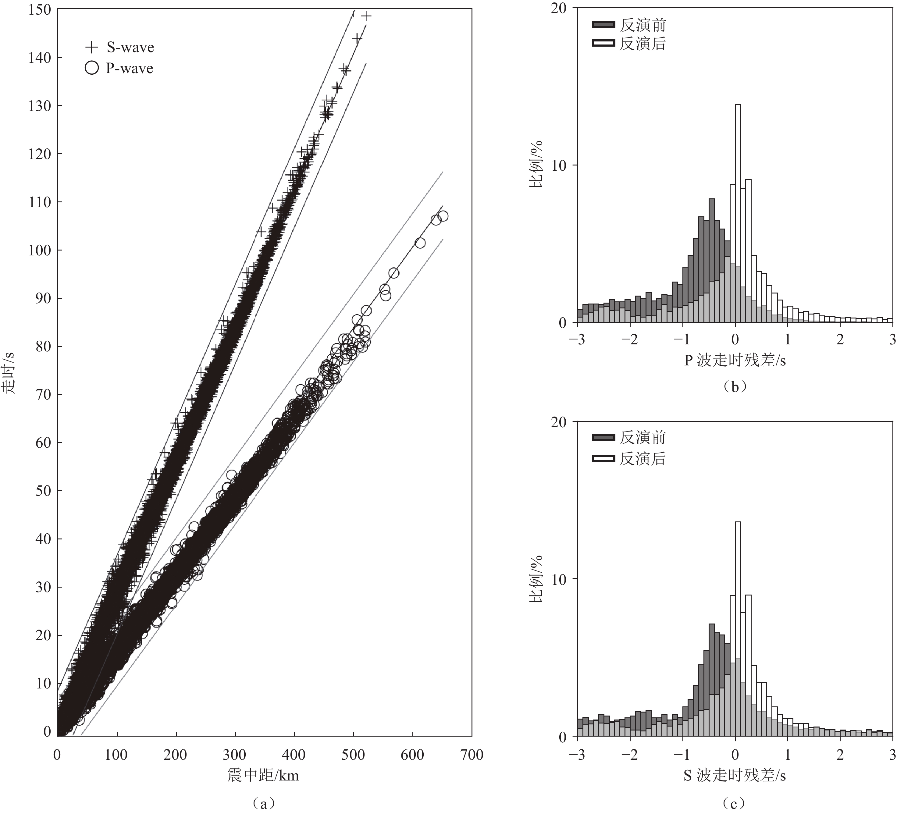
本研究采用近震体波走时层析成像的方法获得研究区域下方的P波、S波速度结构,并由P和S波速度计算得到纵横波速比(VP / VS)。课题组从中国地震局第二监测中心获得地震震相报告,并从震相报告中抽取地震走时数据(图2(a))。为保证数据质量,要求每个地震事件至少被5个地震台站记录到,并且同时包括P波和S波到时。
在进行数据预处理时,对地震事件采用TOMOG3D方法[13]中的地震重定位方法(盖格法)进行了5次迭代确保重定位精度(图3);根据初至震相时距曲线,去除距离时距曲线较远的走时数据,最终获得
8886 个近震事件的44391 条P波初至走时(包含Pn波和Pg波)以及51234 条S波初至走时(包含Sn波和Sg波)(图2(a))。![]() 图 3 研究区域内地震位置分布(发震时间:2010年1月至2020年12月)注:绿色圆点代表重定位前地震震中;红色圆点代表重定位后地震震中;蓝色三角为地震台站;黑色粗线代表主要断层(图1),黑色细线代表小断层;黄色五角星从北至南依次是郯城M8.5大震震中位置、2024年9月安徽肥东地震震中位置。Figure 3. Distribution of the earthquakes that occurred during January 2010 to December 2020 in the study region
图 3 研究区域内地震位置分布(发震时间:2010年1月至2020年12月)注:绿色圆点代表重定位前地震震中;红色圆点代表重定位后地震震中;蓝色三角为地震台站;黑色粗线代表主要断层(图1),黑色细线代表小断层;黄色五角星从北至南依次是郯城M8.5大震震中位置、2024年9月安徽肥东地震震中位置。Figure 3. Distribution of the earthquakes that occurred during January 2010 to December 2020 in the study region图2(b)和图2(c)分别为P波和S波反演前后的走时残差分布。由图可以看出反演前残差统计直方图基本呈现正态分布,平均走时残差约为 −0.5 s,而反演后走时残差分布更加趋近于均值为0的正态分布,表明本研究得到的三维速度结构可以很好地拟合观测的走时数据,即所得速度结构可信。
本研究采用TOMOG3D层析成像方法[10,13]反演近震P波、S波速度结构以及纵横波速度比(波速比,VP / VS)。该方法属于体波走时层析成像方法,类似于医学CT[14]。其成像方法原理简述为:①将地球假定为各向同性并且具有完全弹性的层状介质,将研究区域剖分成许多网格,每个网格节点的速度扰动设为未知参数;研究区域内任意一点的速度扰动可由其周围8个网格节点的速度扰动值进行体积加权插值而得到。②在初始速度模型中,联合使用Snell定律和伪弯曲算法进行三维射线追踪,快速计算震源与台站之间的射线路径和理论走时,同时获得走时对射线所经过网格节点上速度异常的偏导系数(即核函数),构建观测方程。③利用阻尼最小二乘方法求解观测方程组,获得各网格节点上的速度扰动值,对初始模型进行修正,然后重复①~③的步骤。经过多次迭代,得到稳定的成像结果。该方法已被广泛应用于研究全球不同地区的壳幔三维速度结构,涉及诸如板块俯冲、大陆裂解、地幔柱、岩石圈拆沉等地球科学问题[15-16]。
本研究结合时距曲线拟合及前人在研究区研究的一维速度模型[17-18]构建了P波、S波一维参考速度模型(表1)。
表 1 一维参考速度模型Table 1. One-dimensional (1D) references of the P- and S-wave velocity models序号 分层/km VP /(km·s−1) VS /(km·s−1) 1 0~5 4.54 2.65 2 5~10 4.99 2.92 3 10~25 6.33 3.70 4 25~40 7.02 4.11 2. 检测板测试
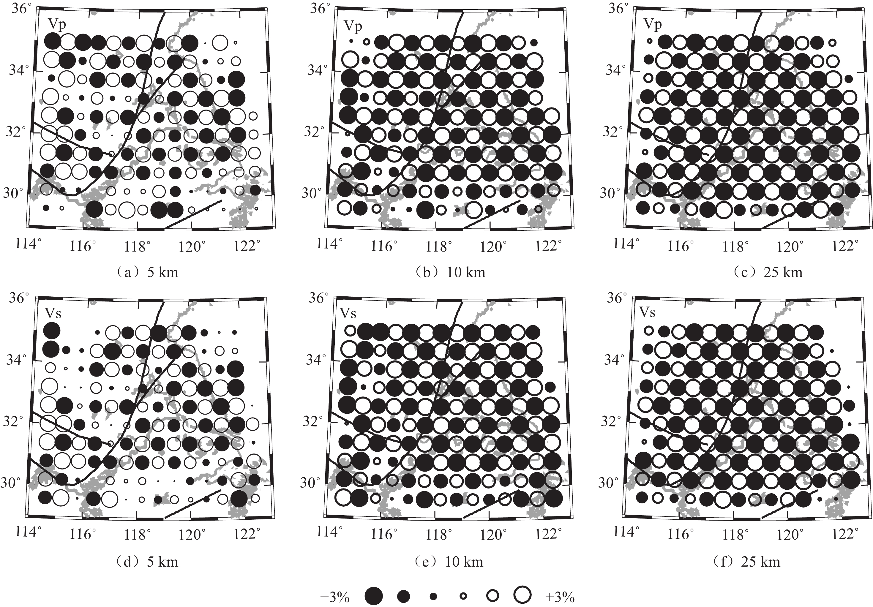
为了确定最佳的网格节点间距,采用检测板测试方法进行空间分辨率测试。基本步骤主要包括:①对研究范围内的地层按照不同网格进行剖分,然后为每一个网格节点设定一定的速度异常值(比如±3%),构建三维理论模型。②利用三维射线追踪技术快速计算每一条射线的理论走时。③对理论走时作为观测数据,采用TOMOG3D方法进行反演,得到新的三维速度模型。④与三维理论模型进行比较,若两者一致,则说明网格剖分合理,否则继续修改网格间距,重新进行上述4步的计算和比较,直到得到最佳网格间距。
本次研究中,对P波与S波速度模型分别进行了0.5°×0.5°、0.6°×0.6°、0.75°×0.75° 等3种水平方向网格试验间距的测试,最终采用在中心区域为0.6°×0.6° 的网格;垂向上分为5、10和25 km深度的3层,分别代表上地壳、中地壳和下地壳。
从图4中可以看出,P波、S波检测板结果基本一致,其中5 km深度处分辨率略差,这与该深度的地震较少有关;而10 km和25 km深度处的分辨率整体较好,这可能与地震分布较多或折射波数据较多有关,也说明这两个深度层上的成像结果更加可信。
此外,较好的空间分辨率还与研究区域内121个固定台站分布较均匀有关(图3)。
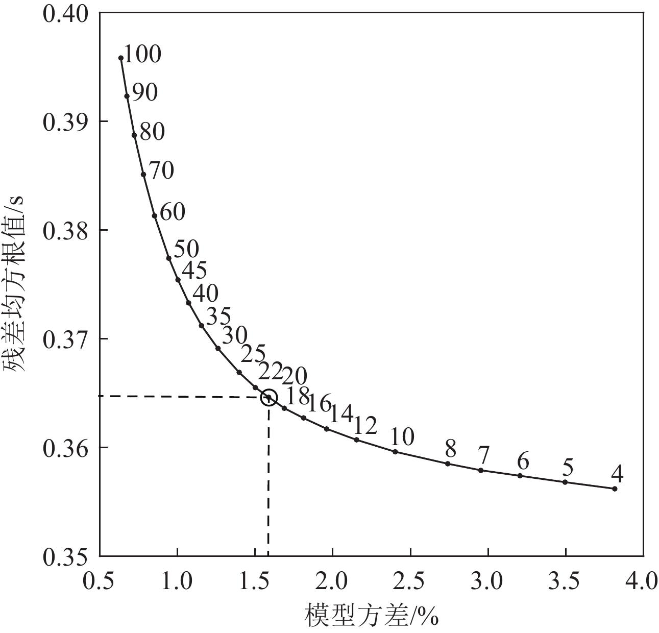
在走时数据反演时,TOMOG3D方法采用阻尼最小二乘法求解观测方程[13]。为获得最佳的阻尼系数,本研究开展不同阻尼系数的测试工作,即在数据反演(成像)过程中设定不同的阻尼系数。根据数据方差和模型方差绘制折中曲线确定最佳阻尼系数。从图5中可以看出阻尼系数为20时,速度异常变化量和走时残差拟合度都得到了很好的平衡。
3. 层析成像结果
3.1 水平剖面结果
在确定阻尼系数、初始参考速度模型和最佳网格间距后,本研究对地震走时数据进行3次迭代反演,获得郯庐断裂带中南段下方5、10和25 km 3个深度层上的P波、S波速度异常结构以及纵横波速比(VP / VS)(图6)。横向上的速度异常呈现出明显不均匀分段性,表现出高、低速异常交替分布的特征,并且与区域内地表的地质构造保持着较好的对应关系。
在5 km深度,大别山造山带表现为明显的P波和S波高速异常以及低VP / VS特征,合肥盆地及东南沿海边缘则表现为P波与S波低速异常以及高VP / VS特征(图6(a)、图6(d)、图6(g))。沿郯庐断裂带从北向南,中段郯城北侧地震分布密集,郯城附近的郯庐断裂两侧出现明显P波与S波高速异常(图6(a)和图6(d)),而郯城附近及苏鲁造山带则显示为高VP / VS特征,但随深度向下在25 km深度处却转换为低速异常(图6(c)和图6(f))。位于郯庐断裂中段的郯城以南宿迁段则在5 km显示为较低的P波和S波速度异常结构,而且地震稀少,与地震空区现象一致;而南段的P波S波显示低速高速交替变化,说明南段的结构比较复杂。
在10 km深度,研究区域内的地震主要集中分布在大别造山带的信阳−舒城断层附近,且处于高、低速异常交界处。大别山造山带东部的低速异常向东延伸至郯庐断裂带,且P波和S波异常均在襄樊−广济附近出现部分低速与高速转换现象。沿郯庐断裂带从南向北,郯城以北显示为中小地震密集区以及明显高速异常。郯城以南宿迁段表现为P波、S波低速异常(图6(b)和图6(e))。此外,大别造山带东侧以及合肥盆地表现出明显高VP / VS特征,而苏鲁造山带、大别造山带则呈现出低VP / VS特征。
在25 km深度,速度异常整体上较为简单和光滑。郯庐断裂带和苏北盆地下方存在明显的低速异常,而其周围则以高速异常为主。相对于中上地壳内的速度,下地壳内的速度发生了部分反转(图6(c)和图6(f)),比如鲁西隆起南部的P波与S波速度由高变低,东南沿海地区黄海南部盆地的速度异常则由低变高。在郯庐断裂带中南段VP / VS呈现有分段性,郯城以北地区表现为高VP / VS异常,而宿迁段下方呈现出低VP / VS结构特征,南段大别山造山带东北缘又呈现为范围较小的高VP / VS结构(图6(h))。这些速度结构特征与何奕成等[19]的体波成像结果相类似,并得到了接收函数高泊松比结果[20]及大地电磁中下地壳低阻高导结果[21]的印证,说明研究区中下地壳可能存在流体作用。
3.2 纵剖面结果
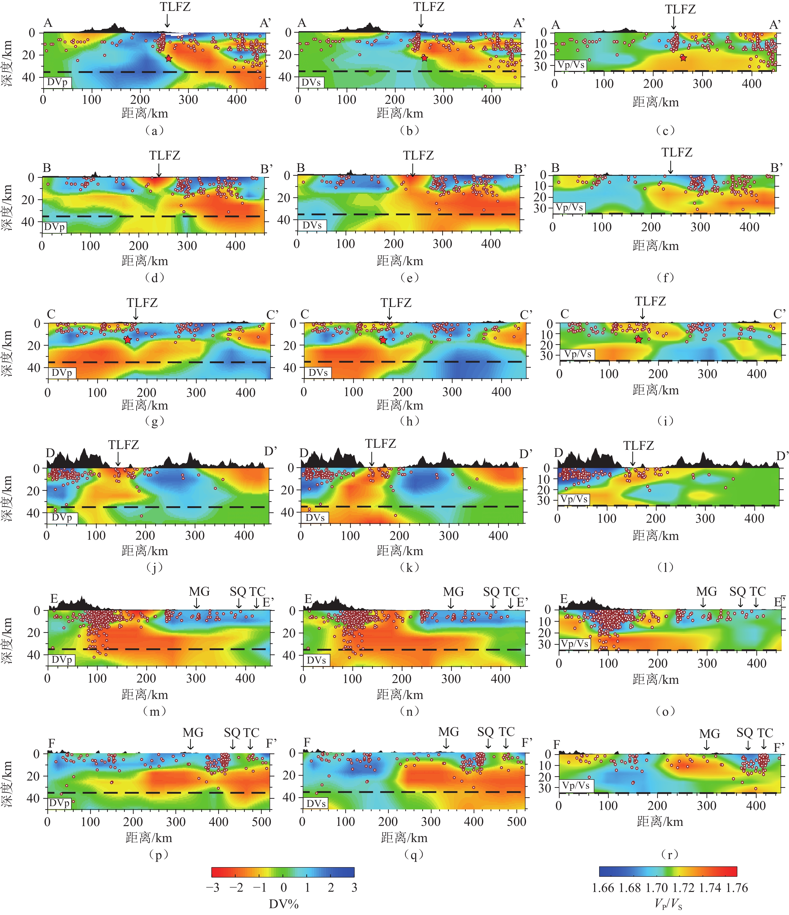
为进一步探讨研究区域地壳内P波和S波速度结构在垂向上的变化以及与地震活动之间的关系,本文沿郯城大地震、郯城−宿迁地震空区、郯庐断裂南段(过合肥肥东地震)、大别造山带东北缘、沿郯庐断裂带两侧分别设计了6条剖线(图6(i)),其成像结果如图7所示。
![]() 图 7 沿纵剖面AA′-FF′ 速度异常结果注:左列、中列和右列分别代表P波速度异常、S波速度异常以及P波与S波比值。白色圆圈代表地震;剖线AA′-FF′位置见图6(i)。红色分别代表低速和高波速比异常,蓝色分别代表高速和低波速比异常,色彩棒位于图的下方。黑色虚线代表莫霍面。(a)~(c)中五角星为郯城地震;(g)~(i)中五角星为2024年9月肥东地震。TLFZ:郯庐断裂带;MG:明光;SQ:宿迁;TC:郯城。Figure 7. Vertical cross-sections of velocity tomography results along different profiles of AA'-FF'
图 7 沿纵剖面AA′-FF′ 速度异常结果注:左列、中列和右列分别代表P波速度异常、S波速度异常以及P波与S波比值。白色圆圈代表地震;剖线AA′-FF′位置见图6(i)。红色分别代表低速和高波速比异常,蓝色分别代表高速和低波速比异常,色彩棒位于图的下方。黑色虚线代表莫霍面。(a)~(c)中五角星为郯城地震;(g)~(i)中五角星为2024年9月肥东地震。TLFZ:郯庐断裂带;MG:明光;SQ:宿迁;TC:郯城。Figure 7. Vertical cross-sections of velocity tomography results along different profiles of AA'-FF'图7展示了沿AA′-FF′ 的6条剖线的P、S波速度异常和波速比VP / VS异常结果。剖面AA′ 经过郯城大地震,从图7(a)~图7(c)中可以看到郯城大地震位于高、低速交界处且靠近高速体。郯庐断裂带下方地震活动密集,周边的中小震群也多发生在高、低速交界处。剖面BB′ 经过郯庐断裂宿迁段地震空区(图7(d)~图7(f)),在郯庐断裂下方几乎没有地震发生。在断裂带下方上地壳内以低速异常为主,两侧为高速异常,而中地壳则显示大范围低速异常,这反映了中地壳的破碎特性以及更稳定的构造环境。剖面CC′ 和DD′ 经过郯庐断裂南段,其中剖面CC′ 经过2024年9月发生在安徽肥东的4.7级地震,震中以为五角星标记在郯庐断裂附近,深度为15 km,也处于高、低速交界处,且周围中小地震频发(图7(g)~图7(i))。
剖面DD′ 经过郯庐断裂南段大别造山带东北缘(图7(j)~图7(l))。该剖面中地震主要集中在郯庐断裂西侧的高速和低波速比异常区内,对应了中小地震频繁的震群区的范围。郯庐断裂下方也存在一些地震,主要分布在低速和高波速比范围内。此外,中下地壳呈现大面积低速异常(图7(j)~图7(k)),可能存在热物质上涌的趋势,与该地区的孕震环境与深部成矿机制有着密切的联系
剖面EE′ 在郯庐断裂西侧由南向北穿过大别高压−超高压变质带、信阳−舒城断裂、合肥盆地等,直至郯城西侧。剖面结果可以看出大别造山带下方上地壳地震十分活跃(图7(m)~图7(o)),大部分地震集中在高速区,少部分分布于低速区中。
从图7(o)中可以看出大部分地震集中在低VP / VS结构内,少量较深的地震发生在高波速比结构内。20 km深度以上的地震发生在低波速比内,可能说明合肥盆地以南断裂交会区存在岩石脆性破裂,而20 km深度以下的地震则可能与深部物质熔融或流体作用相关。下方呈现出往深延伸至中下地壳的明显P波、S波低速异常与断裂等地质构造十分吻合,合肥盆地下方上地壳内存在明显的高速异常,而中地壳内则普遍存在着低速异常体。剖面FF′在郯庐断裂东侧由南向北,上地壳内基本为高速异常,在中下地壳开始转换为大范围低速异常(图7(p)~图7(q))。
根据沿断裂方向的VP、VS速度结构剖面,可以发现郯庐断裂带中南段速度结构从南向北存在着明显差别和分段性。整体上可分为3段:①大别造山带附近剖面速度结构表现为由浅至深的连续高速体;②明光−合肥附近的速度剖面特征以低速为主;③明光西侧以北速度剖面特征主要表现为中上地壳内的高速异常,且高低速分界明显。由此可见,郯庐断裂带中南段速度结构分段的大致位置与断裂活动性分段有较好的一致性。
断裂带活动性分段的主要目的为圈定未来地震危险区提供依据,初步判定郯庐断裂带宿迁段可能存在大震风险,未来应重点关注。
3.3 可恢复测试
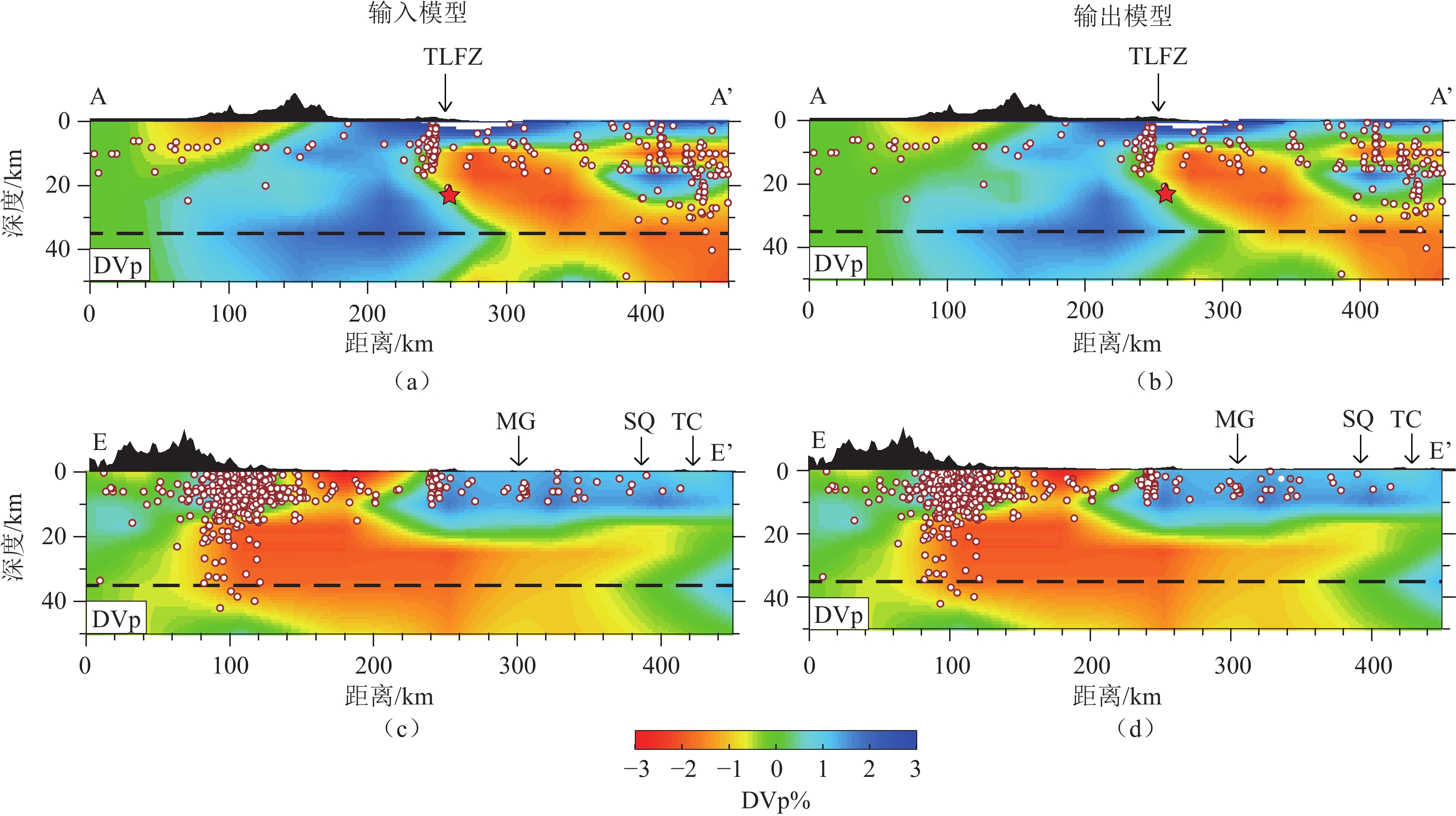
为了更加真实的模拟地下结构,同时验证反演结果的可靠性,本研究进行可恢复测试[13]。其过程与检测板测试基本一致,只是输入的速度模型不同。具体步骤为:将实测数据反演得到的速度结构作为新的初始模型(输入模型),利用三维射线追踪技术在输入模型中计算理论走时;为模拟实测数据的噪声,在理论走时中加入均方根误差为0.15 s的随机噪声生成人工合成数据;对该数据进行反演得到输出模型。当输出模型与输入模型一致时说明成果结果是稳定可靠的(抗噪性强)。
为方便对比,沿AA′ 和EE′ 两条垂直剖面绘制P波的输入和输出模型,如图8所示,其中左侧为输入模型,右侧为对应的输出模型。对比发现,输入模型中的高速和低速异常的主要特征均得到很好恢复,再一次说明本研究反演结果可靠。
![]() 图 8 可恢复测试结果注:(a)和(b)沿剖线AA′的P波可恢复测试结果;(c)和(d)沿剖线EE′的P波可恢复测试结果;左列为输入模型,右列为输出模型。MG:明光;SQ:宿迁;TC:郯城。剖线AA′、EE′位置见图6(i)。Figure 8. Results of the restored test conducted in the present study
图 8 可恢复测试结果注:(a)和(b)沿剖线AA′的P波可恢复测试结果;(c)和(d)沿剖线EE′的P波可恢复测试结果;左列为输入模型,右列为输出模型。MG:明光;SQ:宿迁;TC:郯城。剖线AA′、EE′位置见图6(i)。Figure 8. Results of the restored test conducted in the present study4. 讨论
4.1 速度结构与地震活动分布
本研究成像结果显示合肥盆地下方存在明显的低速特征,从剖面EE′ 结果中可看出与地质构造特征相吻合,符合地质构造盆地和隆起下方的速度结构特征(图7(m)~图7(o))。这与前人利用三维体波成像和背景噪声成像得到的结果基本一致[22-24]。大别山造山带东部在中上地壳表现为高速异常和低VP / VS,下地壳则出现低速异常和高VP / VS(图7(j)~图7(o)),这种结构特征很可能与华北板块与扬子板块的碰撞挤压有关。陆陆碰撞引起的超高压变质带的地壳底部高速、高密度变质岩是其表现为高速异常的直接原因[20]。剖面DD′ 和EE′ 可以看出合肥南侧大别造山带下方上地壳地震十分活跃(图7(m)~图7(o)),也为霍山震群所在区域。该区域地震大部分分布于高速区,少部分分布于低速区中,而低速区域中对应着低VP / VS结构特征。震群位于信阳−舒城断裂附近的复杂构造带内,受大别山造山运动后期拆沉作用诱发的伸展塌陷以及燕山期区域构造应力场方向由NE向挤压转变为近E-W向挤压的影响[25]。地球化学研究表明在震群区附近广泛分布富钾幔源火山岩[26],并且断裂交会区存在弱岩石物理性质,导致出现地震发生区出现低速异常。
本研究结果还显示霍山震群区下方下地壳存在着高VP / VS结构特征(图7(m)),这与已有的体波成像结果[19]、接收函数高泊松比结果[20]相一致,说明研究区中下地壳可能存在着流体作用。
本研究获得的速度结构特征和区域内郯庐断裂带的地震活动之间存在较好的对应关系,既包括了郯庐断裂带中段郯城以北的地震活跃区,也包括了宿迁地震空区。在郯城−明光段(中段),由于该段现代地震活动稀少,被称为宿迁地震空区[4]。郯庐断裂主干上地震较少,主要分布在断裂带两侧的华北板块和扬子板块上。该段速度结构复杂,沿深度方向呈现“低−高−低”的三明治结构特征,即浅地表显示为低速异常,上地壳出现弱高速异常,而在断裂带东侧的中地壳则表现为大范围的低速异常(图7(b)和图7(f))。这种三明治速度结构特征与利用背景噪声成像所得结果相一致[5,24]。
在明光−武穴段(南段)中,中小地震活跃,尤其是在西侧的大别山造山带东北缘信阳−舒城断裂带附近地震活动性则更为强烈。合肥南侧地震尤为密集,该区域速度结构主要受各构造块体影响较大,也为霍山震群所在位置。震群区域地壳介质破碎,断裂纵横交错[19,27],合肥南侧霍山震群均发生在上地壳的高速异常中,下地壳则呈现为明显的低速异常特征,同时在震群区下方还呈现出垂向连续的高波速比异常特征(图7(i)~图7(o))。结果显示霍山震群下方下地壳存在着大范围低速异常结构,低速异常和高Vp / Vs特征结果主要集中在中下地壳深度(图7(m)和图7(n)),可能由于热物质上涌导致,这与前人体波成像[19]以及背景噪声成像[24]结果也有较好的对应关系。
受各个构造块体影响,大别山造山带的构造特征则尤为明显,在郯庐断裂带西侧上地壳主要表现为高速异常,中下地壳则逐渐转变为低速异常和高VP / VS的特征(图7(m)~图7(o)),这与前人上地幔速度成像结果相对应[12]。
4.2 中南段分段性与深部过程
郯庐断裂带中南段具有显著的分段性,分为郯城以北、郯城−明光段、明光−武穴段。郯城以北沿断裂带地震活动频繁,曾发生渤海M 7.0地震和郯城M 8.5地震等强震,地震多聚集在断裂带主干上。郯城−明光段受扬子板块向华北克拉通俯冲的影响较大,存在宿迁段地震空区,明光−武穴段下地壳存在大范围低速异常,则可能受周边构造块体以及热物质上涌的共同影响。大别山造山带中上地壳表现为高速异常,如信阳-舒城断裂带附近中小地震活动多发。这种地震活动分段性特征与地质构造以及地震活动性特征相吻合,可能与扬子板块与华北板块的碰撞俯冲作用密切相关,太平洋板块西向深俯冲也会导致的区域内热物质的横向流动[28],南段中小地震活跃同时也可能受到太平洋板块西向深俯冲的影响。
前人在中国东部更大尺度体波层析成像研究中,对于地幔热物质上涌的动力来源,可能与太平洋板块深俯冲至地幔转换带形成的“大地幔楔”结构的深部动力学结构密切相关[10-11,28],其导致的地幔对流驱动着中国东部下方的热物质上涌至地壳深度。在本研究的结果中,郯城地震、大别造山带下方的下地壳均可以发现低速异常和高VP / VS结构(图6(i))。由于局部构造环境的不同而存在些许差异,但整体处于深受太平洋板块深俯冲影响的中国东部地区,因此在更大尺度上存在着相近的深部力学背景。郯庐断裂带是一条切穿莫霍面、深抵上地幔的深大超壳断裂带[20]。
本研究成像结果显示郯庐断裂南段下方存在明显的低速、高波速比结构,这可能与幔源高温高压热物质或镁铁质基性岩浆沿断裂上涌侵入有关。因此,本文推测研究区在受郯庐断裂带构造活动直接影响的同时,其深部结构与动力学特征与太平洋板块向欧亚板块下方西向深俯冲而形成的“大地幔楔”结构密切相关
5. 结论
本文利用郯庐断裂带周边固定台站的震相数据和地震层析成像方法得到了郯庐断裂带和周边地区P波、S波速度结构以及纵横波速比分布,结合已有的地质学和地震学资料,详细分析了该区域速度结构分布特征,进一步探讨了郯庐断裂带中南段速度结构与地质构造、地震活动分布、深部动力过程之间的关系。
(1)郯庐断裂带中南段地壳速度结构具有显著的分区性,且较大地震主要发生在高、低速异常交界处。郯城以北强震多发且聚集于主干断裂,中段地震活动较弱(甚至出现地震空区),南段则受大别造山带构造块体以及热物质上涌的共同影响,中小地震活动频发。2024年9月安徽肥东M 4.7地震恰处于郯庐断裂南段震群多发的高速异常区域。
(2)中段宿迁地震空区下方从浅至深呈现出“低−高−低”的速度结构特征。这种速度结构的交替变化可能与扬子板块向华北板块的俯冲、碰撞过程相关。
(3)郯城M 8.5大地震和周边的中小震群下方地壳内存在显著的低速和高VP / VS结构,可能与上地幔的热物质上涌有关。结合前人研究,推测研究区在受郯庐断裂带构造活动直接影响的同时,其深部结构与动力学特征可能与太平洋板块向欧亚板块下方西向深俯冲而形成的“大地幔楔”结构密切相关。
致谢:感谢中国地震局第二监测中心提供的地震震相数据。本文绘图中使用了GMT软件[24]。
-
图 3 研究区域内地震位置分布(发震时间:2010年1月至2020年12月)
注:绿色圆点代表重定位前地震震中;红色圆点代表重定位后地震震中;蓝色三角为地震台站;黑色粗线代表主要断层(图1),黑色细线代表小断层;黄色五角星从北至南依次是郯城M8.5大震震中位置、2024年9月安徽肥东地震震中位置。
Figure 3. Distribution of the earthquakes that occurred during January 2010 to December 2020 in the study region
图 7 沿纵剖面AA′-FF′ 速度异常结果
注:左列、中列和右列分别代表P波速度异常、S波速度异常以及P波与S波比值。白色圆圈代表地震;剖线AA′-FF′位置见图6(i)。红色分别代表低速和高波速比异常,蓝色分别代表高速和低波速比异常,色彩棒位于图的下方。黑色虚线代表莫霍面。(a)~(c)中五角星为郯城地震;(g)~(i)中五角星为2024年9月肥东地震。TLFZ:郯庐断裂带;MG:明光;SQ:宿迁;TC:郯城。
Figure 7. Vertical cross-sections of velocity tomography results along different profiles of AA'-FF'
图 8 可恢复测试结果
注:(a)和(b)沿剖线AA′的P波可恢复测试结果;(c)和(d)沿剖线EE′的P波可恢复测试结果;左列为输入模型,右列为输出模型。MG:明光;SQ:宿迁;TC:郯城。剖线AA′、EE′位置见图6(i)。
Figure 8. Results of the restored test conducted in the present study
表 1 一维参考速度模型
Table 1 One-dimensional (1D) references of the P- and S-wave velocity models
序号 分层/km VP /(km·s−1) VS /(km·s−1) 1 0~5 4.54 2.65 2 5~10 4.99 2.92 3 10~25 6.33 3.70 4 25~40 7.02 4.11 -
[1] 冀国强. 郯庐断裂带地壳上地幔速度与各向异性结构研究[D]. 北京: 中国地震局地质研究所, 2024. [2] 李家灵, 晁洪太, 崔昭文, 等. 郯庐活断层的分段及其大震危险性分析[J]. 地震地质, 1994, 16(2): 121-126. LI J L, CHAO H T, CUI Z W, et al. Segmentation of active fault along the Tancheng-Lujiang fault zone and evaluation of strong earthquake risk[J]. Seismology and Geology, 1994, 16(2): 121-126. (in Chinese).
[3] 施炜, 张岳桥, 董树文. 郯庐断裂带中段第四纪活动及其分段特征[J]. 地球学报, 2003, 24(1): 1118. [4] 朱艾斓, 徐锡伟, 王鹏, 等. 以精定位背景地震活动与震源机制解研究郯庐断裂带中南段现今活动习性[J]. 地学前缘, 2018, 25(1): 218-226. ZHU A L, XU X W, WANG P, et al. The present activity of the central and southern segments of the Tancheng-Lujiang fault zone evidenced from relocated microseismicity and focal mechanisms[J]. Earth Science Frontiers, 2018, 25(1): 218-226. (in Chinese).
[5] 孟亚锋, 姚华建, 王行舟, 等. 2019. 基于背景噪声成像方法研究郯庐断裂带中南段及邻区地壳速度结构与变形特征[J]. 地球物理学报, 62(7): 2490-2509. MENG Y F, YAO H J, WANG X Z, et al. Crustal velocity structure and deformation features in the Central-Southern segment of Tanlu fault zone and its adjacent area from ambient noise tomography[J]. Chinese Journal of Geophysics, 2019, 62(7): 2490-2509. (in Chinese).
[6] WEI Z G, CHU R S, CHEN L, et al. Crustal structure in the Middle-Southern segments of the Tanlu Fault Zone and adjacent regions constrained by multifrequency receiver function and surface wave data[J]. Physics of the Earth and Planetary Interiors, 2020, 301: 106470. DOI: 10.1016/j.pepi.2020.106470.
[7] LV Z Q, LEI J S. Seismic evidence for crustal modification across the Tanlu fault zone in eastern China[J]. Geophysical Research Letters, 2022, 49: e2022GL099761. DOI: 10.1029/2022GL099761.
[8] 江国明, 张贵宾, 吕庆田, 等. 长江中下游地区成矿深部动力学机制: 远震层析成像证据[J]. 岩石学报, 2014, 30(4): 907-917. JIANG G M, ZHANG G B, LV Q T, et al. Deep geodynamics of mineralization beneath the Middle-Lower reaches of Yangtze River: Evidence from teleseismic tomography[J]. Acta Petrologica Sinica, 2014, 30(4): 907-917. (in Chinese).
[9] LEI J S, ZHAO D P, XU X W, et al. P-wave upper-mantle tomography of the Tanlu fault zone in eastern China[J]. Physics of the Earth and Planetary Interiors, 2020, 299: 106402. DOI: 10.1016/j.pepi.2019.106402.
[10] ZHAO D P, LEI J, TANG Y. Origin of the Changbai intraplate volcanism in Northeast China: Evidence from seismic tomography[J]. Chinese Science Bulletin, 2004, 49: 1401-1408. DOI: 10.1360/04wd0125.
[11] ZHAO D P, MARUYAMA S, OMORI S. Mantle dynamics of Western Pacific and East Asia: Insight from seismic tomography and mineral physics[J]. Gondwana Research, 2007, 11(1/2): 120-131.
[12] LEI J S. Upper-mantle tomography and dynamics beneath the North China Craton[J]. Journal of Geophysical Research: Solid Earth, 2012, 117(B6): B06313.
[13] ZHAO D P, HASEGAWA A, HORIUCHI S. Tomographic imaging of P and S wave velocity structure beneath northeastern Japan[J]. Journal of Geophysical Research, 1992, 97: 19909-19928. DOI: 10.1029/92JB00603.
[14] 和锐, 杨建思, 张翼. 地震层析成像方法综述[J]. CT理论与应用研究, 2007, 16(1): 35-48. HE R, YANG J S, ZHANG Y. A review on the technology of seismic tomography[J]. CT Theory and Applications, 2007, 16(1): 35-48. (in Chinese).
[15] 冯梅, 安美建. 基于面波频散的三维横波速度方位各向异性层析成像方法[J]. CT理论与应用研究, 2020, 29(4): 381-397. DOI: 10.15953/j.1004-4140.2020.29.04.01. FENG M, AN M J. Method on 3D tomography of S-wave velocity azimuthal anisotropy by using surface-wave dispersion curves[J]. CT Theory and Applications, 2020, 29(4): 381-397. DOI: 10.15953/j.1004-4140.2020.29.04.01. (in Chinese).
[16] 刘晏廷, 钟成城, 江国明, 等. 西北太平洋板块边缘俯冲特征: 来自堪察加壳幔速度成像的约束[J]. CT理论与应用研究, 2024, 33(2): 135-148. DOI: 10.15953/j.ctta.2023.223. LIU Y T, ZHONG C C, JIANG G M, et al. Subduction dynamics at the northwestern pacific slab edge: Constraints of tomography in Kamchatka[J]. CT Theory and Applications, 2024, 33(2): 135-148. DOI: 10.15953/j.ctta.2023.223. (in Chinese).
[17] WANG J, ZHAO D P. P-wave anisotropic tomography beneath Northeast Japan[J]. Physics of the Earth and Planetary Interiors, 2008, 170(1/2): 115-133.
[18] 黄耘, 李清河, 张元生, 等. 郯庐断裂带鲁苏皖段及邻区地壳速度结构[J]. 地球物理报, 2011, 54(10): 2549-2559. DOI: 10.3969/j.issn.0001-5733.2011.10.012. HUANG Y, LI Q H, ZHANG Y S, et al. Crustal velocity structure beneath the Shandong-Jiangsu-Anhui segment of the Tancheng-Lujiang fault zone and adjacent areas[J]. Chinese Journal of Geophysics, 2011, 54(10): 2549-2559. DOI: 10.3969/j.issn.0001-5733.2011.10.012. (in Chinese).
[19] 何奕成, 范小平, 赵启光, 等. 郯庐断裂带中南段地壳结构分段特征[J]. 地球物理学报, 2021, 64(9): 3164-3178. DOI: 10.6038/cjg2021O0247. HE Y C, FAN X P, ZHAO Q G, et al. 2021. Segmentation of crustal structure beneath the middle-south segment of Tan-Lu Fault Zone[J]. Chinese Journal of Geophysics, 64(9): 3164-3178. DOI:10.6038/cjg2021O0247. (in Chinese).
[20] 顾勤平, 李大虎, 丁志峰, 等. 利用接收函数研究郯庐断裂带鲁苏皖段及邻区地壳结构特征[J]. 地球物理学报, 2022, 65(9): 3280-3296. DOI: 10.6038/cjg2022P0926. GU Q P, LI D H, DING Z F, et al. 2022. Crustal structure characteristics beneath the Shandong-Jiangsu-Anhui segment of the Tan-Lu fault zone and its adjacent regions using receiver functions[J]. Chinese Journal of Geophysics, 65(9): 3280-3296. DOI: 10.6038/cjg2022P0926. (in Chinese).
[21] 崔腾发, 陈小斌, 詹艳, 等. 安徽霍山地震区深部电性结构和发震构造特征[J]. 地球物理学报, 2020, 63(1): 256-269. DOI: 10.6038/cjg2019M0458. CUI T F, CHEN X B, ZHAN Y, et al. 2020. Characteristics of deep electrical structure and seismogenic structure beneath Anhui Huoshan earthquake area[J]. Chinese Journal of Geophysics, 63(1): 256-269. DOI:10.6038/cjg2019M0458. (in Chinese).
[22] 徐纪人, 杨文采, 赵志新, 等. 苏鲁大别造山带岩石圈三维P波速度结构特征[J]. 地质学报, 2003, 77(4): 577-582. XU J R, YANG W C, ZHAO Z X, et al. Three-dimensional velocity structures of the Sulu-Dabie orogen belt[J]. Acta Geologica Sinica, 2003, 77(4): 577-582. (in Chinese).
[23] CUI X, SONG X Q, XU L S, et al. Three-dimensional crustal P-wave structure beneath the central south segment of the Tanlu Fault Zone determined by local earthquake travel-time tomography[J]. Terra Nova, 2021, 33(6): 613-620. DOI: 10.1111/ter.12553.
[24] LUO S, YAO H J, LI Q S, et al. High-resolution 3D crustal S-wave velocity structure of the Middle-Lower Yangtze River Metallogenic Belt and implications for its deep geodynamic setting[J]. Science China Earth Sciences, 2019, 62(9): 1361-1378. DOI: 10.1007/s11430-018-9352-9.
[25] 洪德全, 王行舟, 李军辉, 等. 利用远震接收函数研究安徽地区地壳厚度[J]. 地震地质, 2013, 35(4): 853-863. DOI: 10.3969/j.issn.0253-4967.2013.04.014. HONG D Q, WANG X Z, LI J H, et al. Study on the crustal thickness beneath stations of seismic network in Anhui province by teleseismic receiver function[J]. Seismology and Geology, 2013, 35(4): 853-863. DOI: 10.3969/j.issn.0253-4967.2013.04.014. (in Chinese).
[26] 刘亮, 邱检生, 李真. 浙江沐尘石英二长岩及其镁铁质包体的锆石U-Pb年龄和Hf同位素组成——对岩浆混合作用的示踪[J]. 地质论评, 2011, 57(3): 327-336. DOI: 10.16509/j.georeview.2011.03.009. QIU J L, HU J S, LI Z. Zircon U-Pb age and Hf isotopic compositions of quartz monzonite and enclosed mafic enclaves in muchen pluton, Zhejiang province: Tracing magma mixing in their petrogenesis[J]. Geological Review, 57(3): 327-336. (in Chinese).
[27] 贾科, 周仕勇. 断层相互作用与地震触发机制研究回顾与展望[J]. 地球与行星物理论评(中英文), 2023. 54(5): 477-497. DOI: 10.19975/j.dqyxx.2022-071. JIA K, ZHOU S Y. Fault interaction and earthquake triggering mechanisms: Progress and prospects[J]. Reviews of Geophysics and Planetary Physics, 2023, 54(5): 477-497. DOI:10.19975/j.dqyxx.2022-071. (in Chinese).
[28] HUANG J L, ZHAO D P. High-resolution mantle tomography of China and surrounding regions[J]. Journal of Geophysical Research: Solid Earth, 2006, 111(B9): B09305.


 下载:
下载:
